


Project Overview
Alpartir Project covers an area of 576 km2 and consists of three Investigation Permits (P.I.) under application and five granted Exploration Permits (P.E.) (Figure 1; Table 1). Ground disturbing exploration activities, including drilling, are planned for the P.I.’s after the permits are granted. Geological mapping, geochemical sampling and airborne geophysics are currently underway within the P.E.’s.
The Project comprises a series of historically worked Ag–Cu vein deposits, centred on the Bilbilitana and Colosal Platífera mines (Alpartir mine), situated within the Paleozoic basement rocks of the Iberian Range.
The acquisition of the Alpartir Project is complimentary to the Company’s existing Iberian Copper Project. Consistent with the Iberia Copper Project, it represents a strategic entry into a historically productive European Ag-Cu-Sb district with strong geological foundations and significant exploration upside.
Permit Name |
Permit type |
km² |
Cuadriculars |
Interest |
Status |
Alpartir |
Investigation |
65.54 |
226 |
80% |
Pending |
Grio |
Investigation |
34.22 |
118 |
80% |
Pending |
Cosuenda |
Investigation |
6.67 |
23 |
80% |
Pending |
Tobed |
Exploration |
93.96 |
324 |
80% |
Granted |
Encinacorba |
Exploration |
93.96 |
324 |
80% |
Granted |
Cerveruela |
Exploration |
93.96 |
324 |
80% |
Granted |
Villalhuerto |
Exploration |
93.96 |
324 |
80% |
Granted |
Africana |
Exploration |
93.96 |
324 |
80% |
Granted |
|
Total |
576.23 |
1,987 |
|
|
Table 1 – Alpartir Permit List.
See ASX Announcement “MEG Secures Option to Acquire Silver-Copper Project” dated 2 March 2026.
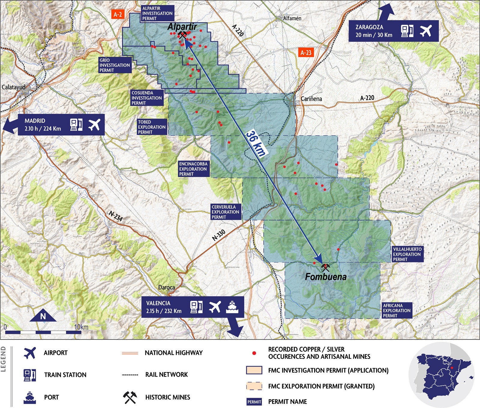
Figure 1 – Map showing location of permits in Alpartir Project.

Figure 2 – 31 documented historical mines and 65 documented vein occurrences
Historical Mining
Mining at the Project dates to Roman times, with renewed exploitation in the mid-19th and early 20th centuries (Calvo Rebollar & Calvo Sevillano, 2019 ⁴). Prospective structures and historical mines have been documented over a distance of more than 36 kilometres, from Bilbilitana/Colosal Platífera in the north to Fombuena in the south, with permits covering the full extent of the prospective zones.
Historical records from the most well-known of the historic mines, Bilbilitana, report copper concentrates grading approximately 20–30% Cu and 64–160 oz/t Ag (González, 1857 ⁶; cited in Calvo Rebollar & Calvo Sevillano, 2019 ⁴). Mining grades were reported to be improving with depth with no mining occurring below approximately 60 metres (Source: Calvo and Calvo, 2019 ⁴; González Lasala, 1857 ⁶).
Records from the Fombuena mine in the south document a vein or layer greatly exceeding 1m thickness. However, mining encountered more water than expected and could not be dewatered at the time. Efforts to construct steam driven dewatering were ineffective and ultimately the mine was abandoned.
Operations ceased in the early 20th century due to limited scale, metallurgical challenges and financial management issues, rather than confirmed depletion of the mineral system (Calvo Rebollar & Calvo Sevillano, 2019 ⁴).
Historical Exploration
Asturiana de Zinc (AZSA), now part of Glencore, undertook a regional geochemical sampling program across the Project in 1969. Sampling was primarily focused on the historical workings and vein extensions in the townships of Alpartir, GrÍo and Tobed (Figure 3).
The AZSA sampling program highlights the potential for exceptionally high-grade silver and high-grade copper (Table 1; Figure 4; Appendix A), with the Alpartir mine showing bonanza-level silver values. Several high-silver samples show significant antimony (Sb) content, indicating silver-bearing tetrahedrite or complex sulfosalt mineralisation.
Sample |
Township |
Ag(oz/t) |
Cu% |
Sb% |
A-29 |
Alpartir |
46.0 |
3.93 |
1.89 |
A-25 |
31.8 |
7.57 |
- |
|
A-3 |
25.1 |
6.17 |
- |
|
A-27 |
20.8 |
3.69 |
- |
|
A-22 |
8.0 |
10.66 |
- |
|
A-7 |
13.1 |
3.08 |
- |
|
A-26 |
11.7 |
1.29 |
- |
|
T-1 |
Tobed |
40.2 |
5.14 |
- |
T-15 |
14.5 |
1.97 |
- |
|
T-13 |
12.5 |
1.47 |
- |
|
C-1 |
Codos |
42.4 |
3.89 |
1.66 |
Table 2 – Top 11 for the Alpartir rock chips.


Figure 4 – Map showing historical rock chip assays by Asturiana de Zinc (AZSA).
Geological Setting
The Project is within the Herrera Unit of the Iberian Range with mineralisation hosted by Ordovician–Silurian quartzites and slates, principally within the Armorican Quartzite Formation. The region forms part of the Calatayud–Montalbán Massif and has undergone Hercynian and later Alpine deformation, resulting in structurally controlled vein emplacement.
Mineralisation Style
Historical mining focused on steeply dipping vein–breccia structures, particularly at the Bilbilitana mine, where mineralisation fills a fault breccia between 1 and 3 metres thick. Veins dip steeply (~80°) and trend approximately NW–SE to NNW–SSE, with lateral extensions of >1,000 metres (Figure 5). Vein emplacement is interpreted to be associated with regional Hercynian and Alpine fault systems (Artiaga Torres et al., 2011 ³).
The Alpartir deposit is characterised by a silver-bearing Sb–Cu (Ag) paragenesis, with:
- Tetrahedrite (Ag-bearing) – principal ore mineral
- Chalcostibnite (Cu–Sb sulfosalt) – abundant
- Accessory sulphides including chalcopyrite, sphalerite, galena, pyrite and arsenopyrite
- Gangue minerals dominated by siderite and quartz

Figure 5 – Geological map of historic Alpartir mine area (modified from Artiaga et al., 2011).
References
¹Asturiana de Zinc (AZSA) (1969). Relacion de Muestras Correspondientes al Permiso de Investigacion “Elena”. Asturiana de Zinc, S.A.
²Laboratorio. Report of Samples Corresponding to the Exploration Permit “Elena”. Asturiana de Zinc, S.A. Laboratory.
³Artiaga Torres, D., Colomer Lorenzo, J.M., Melgarejo, J.C., Proenza, J.A., Mata & Perelló, J.M. (2011). Nuevos Datos sobre las Minas de Plata de Alpartir (Zaragoza). Translated title: New Data on the Silver Mines of Alpartir (Zaragoza).
⁴Calvo Rebollar, M. & Calvo Sevillano, G. (2019). Las Minas de Cobre y Plata de Alpartir (Zaragoza, España). Historia y Patrimonio Minero. Translated title: The Copper and Silver Mines of Alpartir (Zaragoza, Spain): History and Mining Heritage. De Re Metallica, No. 32, pp. 73–86.
⁵García Gil, E., Vindel Catena, E., & Lunar Hernández, R. (1987). Estudio metalogénico de la mineralización de cobres grises de Alpartir (Zaragoza). Translated title: Metallogenic Study of the Fahlore Copper Mineralization of Alpartir (Zaragoza).
⁶González Lasala (1857). Sobre el estado y el porvenir de la provincia de Zaragoza. On the state and future of the province of Zaragoz.
Latest Announcements

Megado Minerals Limited
ABN: 74 632 150 817
Head Office
Calle de Silva n°2.
2 planta Despacho 1,
MADRID, ESP

Site designed by
Day Dot Design Studio
Site implemented by
Captured Pixels