


Project Overview
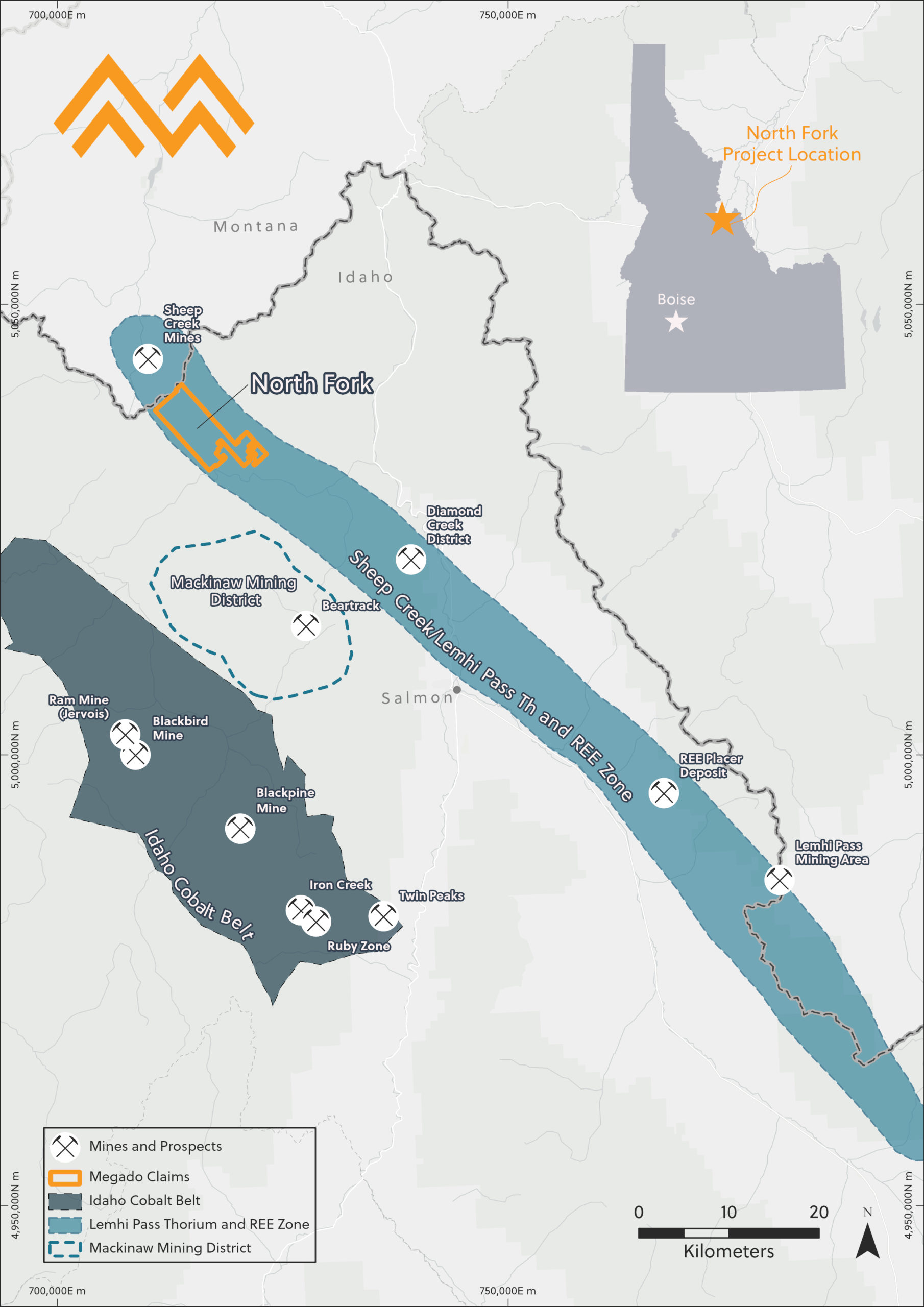
The North Fork Rare Earth Project is located 40 km north-west of Salmon in the Salmon‐Challis National Forest, Lemhi County, Idaho.
The North Fork Rare Earth Project includes 499 unpatented mining lode claims covering approximately 10,309 acres (42 km2).
The claims include historically known areas of anomalous rare earth mineralization in the North Fork ‘mineralized trend’. This mineralized trend is a north‐south oriented belt approximately 2.9 km wide and 30 km long running from the Indianola Ranger station on the Salmon River northwest into Montana.

Project Setting
The North Fork Rare Earth Project is located at an elevation of about 1,000–2,100 meters. This area of Idaho can receive snowfall starting in late October lasting through the end of May. The project area is situated in the Salmon River Mountain range as part of the Rocky Mountain Cordillera and has a semi-arid climate with average annual low and high temperatures between -1°C and 15°C. Vegetation at the project consists of low growing shrubbery, various grasses, and pine forests.
Access to North Fork from major cities is by highway, driving from Idaho Falls or Missoula, both of which have commercial airports and are approximately 2.5 hours drive from Salmon. The state capital, Boise, is 5 hours drive from the project. Prospect areas at North Fork are served by existing roads previously used for logging operations.
Geology
The rare earth mineralization at North Fork is emplaced as an igneous carbonatite intrusion, hosted in ancient Proterozoic metamorphosed Belt Supergroup amphibolites and augen gneisses. The mineralization is located primarily in the carbonatite magmatic dikes and sills or “veins” with minor observed secondary porphyry overprinting and alteration.
The geologic history of the area is complex as many faults, igneous intrusions, and late Cenozoic volcanism intersect on the North Fork Project properties. Mineralization is inferred to be associated with a, as yet unidentified, subsurface syenite‐peralkaline intrusion located in the area.
The North Fork Rare Earth Project veins are structurally controlled (emplaced along faults, fractures, and foliation) and have been historically shown to be associated with some niobium and minor thorium mineralization (Avg. less than 165 ppm thorium). Detailed mineralogy is the subject of this current investigation; however, historical data suggests the important mineralogy is principally monazite and allanite with minor amounts of other associated rare earth minerals.


Prospects
Historically, limited exploration has been conducted in the area. During the 1950’s the US Geological Survey (USGS), the Idaho Bureau of Mines and Geology (IBMG) and the Atomic Energy Commission (AEC) investigated the occurrence of thorium, associated rare earth elements and niobium within the North Fork Area. These early investigations led to the property being staked in the early 2000’s.
Exploration in the 2000’s at Silver King and Jackpot prospects yielded indications of highly significant mineralization. A Jackpot prospect vein has been traced along the surface for 400m with historical trench results of 0.76m @21.5% TREO and 0.76m @ 14.5% TREO.
Silver King contains two known veins of approximately 210 and 170 metres exposed at surface and costean (channel) sampled. The Silver King vein samples had high concentrations of total rare earth oxides (TREO) with the North Vein and South Vein returning 10.3% TREO and 5.8% TREO, respectively. These Silver King North and South Veins also showed significant critical rare earth (Y, Nd, Tb, Dy, Er) content with total critical rare earth (CREO) sample grades of 1.17% CREO and 0.7% CREO. Additional historical trench results at Silver King have returned 1.52m @ 17.7% TREO.
North Fork Rare Earth Project – Exploration Agreement Signed*
On 19 December 2024, the Company signed an Exploration Agreement with Option to Purchase with PURE Exploration (USA) LLC, a wholly owned subsidiary of Iluka Resources. The agreement covers the North Fork Rare Earth Project in Idaho, USA, allowing PURE Exploration to explore the site and potentially acquire the project based on the results.
Latest Announcements

Megado Minerals Limited
ABN: 74 632 150 817
Head Office
Calle de Silva n°2.
2 planta Despacho 1,
MADRID, ESP

Site designed by
Day Dot Design Studio
Site implemented by
Captured Pixels